
Predicted Distribution Map
The green area shows the predicted habitats for this species.
© NatureMapping Program
+ enlarge map
Predicted distribution map
 = Core Habitat = Core Habitat
|
|
Fact Sheet:
Advanced (Grades 7-12) |
Español
(Data about data or how the map was made)
Predicted Distribution
The purpose of the vertebrate distribution maps is to provide more precise information about the current distribution of
individual native species within their general ranges than is generally available from field guides.
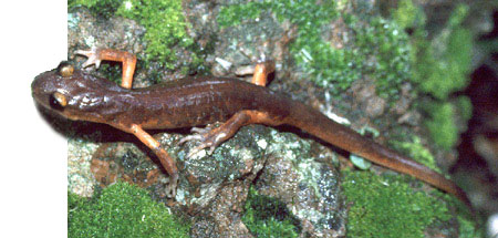
Amphibians do not migrate as birds do, so the colored areas depict the predicted range for
the Ensatina year-round. The habitats were identified using satellite imagery, other datasets and experts throughout the state, as part of the California Gap Analysis Project.
Species Observations (dots)
The green area shows the predicted habitats for this species.
© NatureMapping Program
|