Home | About Us | Maps | Animal Facts
GAP Analysis Predicted Distribution Map
Home | About Us | Maps | Animal Facts
Species Code: COBR
|
Habitat
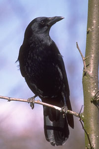
These Crows are common in most open habitats near populated areas. They can occur in a number of habitats, including cities, residential areas, farmlands, managed forests, and coastal areas. With the exception of the coastal birds, most American Crows are tied directly to the presence humans. In the Columbia Basin this species is expanding its range.
Core zones were those below the Silver Fir zone (west side) and below the Sub-alpine Fir zone (east side), as well as peripherally in the Silver Fir zone. Core west-side forested zones were all good habitats except bare ground and closed canopy mid- to late-seral conifer forest in the Sitka Spruce and Western Hemlock zones. In the peripheral Fir zone, forest openings and clearings were good.
Formerly, many authorities considered the coastal crows of our region to be separate species, the Northwestern Crow, but most experts in our area now consider the two forms to be one species. The Northwestern Crow is the form adapted for foraging in coastal areas from Washington north to coastal Alaska; the American Crow is the widespread form found throughout North America.
Translated from the Washington Gap Analysis Bird Volume by Uchenna Bright
Text edited by Gussie Litwer
Map by Dave Lester

 = Core Habitat
 = Marginal Habitat