Home | About Us | Maps | Animal Facts
GAP Analysis Predicted Distribution Map
Home | About Us | Maps | Animal Facts
Species Code: ORAM
|
Habitat
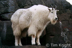
Mountain Goats are found in Washington in the Cascades, Selkirks, and have been introduced to the Olympics. Their primary habitat requirement is rugged terrain such as steep, rocky cliffs, projecting pinnacles, ledges, and talus slides. They tend to prefer the area near treeline, but may move to lower altitude cliffs in winter. They use conifer forest for cover and feed mostly on early successional vegetation in meadows and slides.
Core zones are Mountain Hemlock, Silver Fir, Sub-alpine Fir, Alpine/Parkland, and High Lava Flows. Steep, rugged topography is as important as vegetation to Mountain Goats. Lower zones may be adequate for them if they are near steep slopes and the higher core zones. Non-forested habitats were good.
Translated from the Washington Gap Analysis Mammal Volume by Dave Lester
Design by Tim Knight; Photo: Tim Knight

 = Core Habitat
 = Marginal Habitat