Washington Gap Analysis
|
What is Gap Analysis?
View a movie about Gap
Analysis. Gap Analysis is a process of identifying areas of high conservation priority. It is designed to be a
proactive approach to conservation. Gap relies on information about current landcover and terrestrial
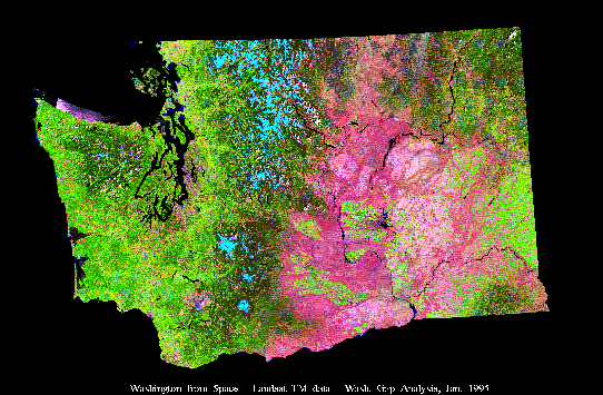
vertebrates to identify habitat types and species that are poorly represented on reserves. Predicted distribution mapsThe predicted vertebrate distribution maps are included in the "Maps" section on the The NatureMapping Program web site. The distribution narratives have been summarized.The Washington Gap Analysis GIS range maps can be downloaded, from the Washington State Department of Fish and Wildlife Web site. Printed VolumesThe final printed volumes are available for purchase through the Washington Cooperative Fish and Wildlife Research Unit.Description of the actual land cover of Washington State mapped using 1991 satellite (TM) imagery. The 31 vegetation zones within the state are the major framework for the analysis. The analysis for each zone (e.g., Ponderosa Pine Zone) includes a description of the natural land cover, the current land cover, and its conservation status. Maps of generalized land cover and conservation status categories are included (3 - 24x36" color maps). Volumes 2-4 include narratives for each species include a brief description of habitat requirements and how the distributions were modeled. On the facing page, a map of the predicted distribution with known locations (museum records or, for birds, the Seattle Audubon Society's Breeding Bird Atlas data) is provided. These atlases contain the most current and detailed distribution maps for terrestrial vertebrates in the state. (Published by the Seattle Audubon Society - out-of-print) A detailed analysis of the conservation status of land cover and vertebrate species (excluding fish) in the state. Analyses are presented for each of the 31 vegetation zones and the entire state, and provide a landscape context for biodiversity conservaiton and natural resource management (9 color maps). The project was funded by the United States Geological Survey (USGS) Biological Resources Division, through the Washington Cooperative Fish and Wildlife Research Unit at the University of Washington. To read a more detailed account about Gap go to the National Gap homepage. Washington Gap Analysis ProjectWashington Cooperative Fish and Wildlife Research Unit University of Washington Box 355020 Seattle, WA 98195-5020 (206)543-6475 The Washington Gap Analysis team: Kelly Cassidy, Ph.D. Now lecturing at Washington State University, Pullman Karen Dvornich (206) 616-2031 vicon@u.washington.edu Christian Grue, Ph.D. (206) 543-6475 cgrue@u.washington.edu Michael Smith, M.S. Now with the US Fish and Wildlife Service |