Home | About Us | How to Participate | Biodiversity Modules | Projects | Maps | News | Resources
Home | About Us | How to Participate | Biodiversity Modules | Projects | Maps | News | Resources
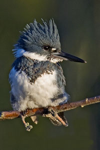
Species Code: CEAL
|
Metadata (Data about data or how the map was made)
Habitat
This species was common in freshwater and estuarine habitats throughout the state at low and moderate elevations. They nest in burrows and sandy banks and are not normally found in high-elevation lakes due to low prey availability.
Good habitat in the core areas of use included all wetlands below the Sub-alpine Fir and Mountain Hemlock zones throughout the state.
The Washington breeder subspecies is the western form C. a. caurina, though some authorities discount this geographic variation. Apparently the major limiting factors in Belted Kingfisher distribution are prey and nest-site availability. Records come from throughout the state, mostly at low to moderate elevations. Fairly high elevation breeding-season records come from Dewey Lake at Chinook Pass, and a high sub-alpine marsh alone the Chewack River. Nests are three- to six-foot deep burrows in high sand banks.
Translated from the Washington Gap Analysis Bird Volume by Uchenna Bright
Text edited by Gussie Litwer
Webpage designed by Dave Lester

 = Core Habitat
 = Marginal Habitat