Home | About Us | How to Participate | Biodiversity Modules | Projects | Maps | News | Resources
Home | About Us | How to Participate | Biodiversity Modules | Projects | Maps | News | Resources
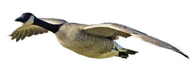
Species Code: BRCA
|
Habitat
This species is locally common throughout the lowlands of the state in the wetlands and waterways, cities, and agricultural areas (except the extensive dryland fields of eastern Washington). In western Washington, they can be found along river valleys to fairly high elevations, such as those at Ross Lake in Whatcom County. They can also be found along the Snoqualmie River in the west at least to North Bend. In eastern Washington, they are generally found in appropriate habitat below the Ponderosa Pine zone, but they are present in some areas in that zone, e.g., along the major northern river valleys and at the west end of Lake Chelan. Other higher elevation sites area Rimrock Lake in Yakima County and Trout Lake in Klickitat County. On the Olympic Peninsula, the Canada Goose is apparently absent on the outer coast north of Gray's Harbor, and east of Cape Flattery to Port Angeles. Along the eastern rivers, Canada Geese often nest on very rocky cliffs above the rivers.
Good habitat in the core areas of use included all freshwater bodies and wetlands, except conifer-dominated riparian areas below Silver Fir on the west side and all zones up to and including Interior Douglas-fir on the east side. The Grand Fir zone, which is also on the east, was the peripheral area of use. Low-density development agriculture on the west side and irrigated agriculture on the east side were included knowing there may be smaller pockets of habitat suitable for them.
Canada Geese are common in many developed areas, especially on grassy lawns, as long as a source of water is near. Canada Geese were not common prior to 1900 because a lack of habitat and over-hunting caused a decline in their numbers in the late 1800s and early 1900s. Conversions of land to agriculture, increasing food supply in the cities (in the form of manicured grassy fields), changes from river traffic to rail traffic (boats to trains), and game laws all contributed to an increased Canada Goose population in this century. In eastern Washington, many individuals are non-migratory due to abundant food available year-round and the lack of predators.
Translated from the Washington Gap Analysis Bird Volume by Uchenna Bright
Text edited by Gussie Litwer
Webpage designed by Dave Lester

 = Core Habitat
 = Marginal Habitat