Home | About Us | How to Participate | Biodiversity Modules | Projects | Maps | News | Resources
GAP Analysis Predicted Distribution Map
Home | About Us | How to Participate | Biodiversity Modules | Projects | Maps | News | Resources
Species Code: CEUR
5 March 2010 - the US FWS announced that the bird warranted listing under the Endangered Species Act, but would be "precluded" by higher priorities - other species that are in greater danger - according to the US Interior Secretary.
|
Habitat
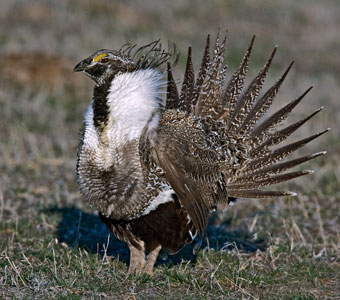
This species is uncommon, very local, and declining in sagebrush lands in central Douglas County and in the U.S Army's Yakima Training Center. There are remnant populations in Benton County and Lincoln County, but they are on the verge of extirpation. They were formerly found throughout the lower areas of the Columbia Basin wherever large tracts of sagebrush occurred.
Good habitat in the core areas of use were all steppe habitats (except sparse vegetation) in the Central Arid Steppe, Big Sage/Fescue, and Three-tip Sage zones, but are limited geographically to the regions mentioned above where known breeding populations still exist.
Confirmed records of this species are rare because of the difficulty of locating grouse nests and the danger of disturbance to nests. Documentation shows that Sage Grouse were formerly found throughout the central Columbia Basin in areas of healthy sagebrush. In fact they have been recorded throughout the region, including near Ellensburg, Spokane, and Toppenish. They have also been reported near Creston, but there are no recent records from this area. Based on historic range maps and our modeled distribution, Sage Grouse occupy approximately between 10% and 30% of their former area in Washington, with only about 600 birds left. Principal sources of the decline include unrestricted hunting in early 1900s (they were legally hunted until 1988), and habitat destruction (overgrazing, conversion to agriculture).
Translated from the Washington Gap Analysis Bird Volume by Uchenna Bright
Text edited by Gussie Litwer
Webpage designed by Dave Lester

 = Core Habitat
 = Marginal Habitat