Home | About Us | How to Participate | Biodiversity Modules | Projects | Maps | News | Resources
GAP Analysis Predicted Distribution Map
Home | About Us | How to Participate | Biodiversity Modules | Projects | Maps | News | Resources
Species Code: AEOC
|
Metadata (Data about data or how the map was made)
Habitat
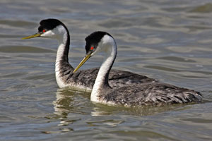
This species is locally common on large ponds and reservoirs in arid areas of eastern Washington, especially Moses Lake and Potholes Reservoir in Grant County. This grebe is also known from ponds along Crab Creek and Frenchman Hills Waterway, in many ponds in the Columbia National Wildlife Refuge, and other locations including Lake Lenore and Banks Lake.
Good habitats in core areas of use were freshwater/wetlands in the Central Arid Steppe and Big Sage/Fescue zones.
Outside of the mapped distribution, Western Grebes may be found as non-breeding summer residents or migrants. During the nesting season this species is highly colonial. Colonies are formed as a few pairs nest among developing vegetation, followed by more pairs nesting as "satellites", and so on until there are many pairs nesting in a fairly large colony. The nest is a floating vegetation mat anchored to developing vegetation. The 'possible' BBA records along the Columbia between Kittitas and Grant Counties are most likely of non-breeding individuals, since the river is deep, flanked by steep cliffs, and has little suitable emergent vegetation in the area.
Translated from the Washington Gap Analysis Bird Volume by Uchenna Bright
Text edited by Gussie Litwer
Webpage designed by Dave Lester

 = Core Habitat
 = Marginal Habitat